Capacity Building for Minimising Climate Risks
T
he explicit issue of climate change has a broad spectrum of impacts on the human civilisation, ranging from erratic weather patterns to lowered crop yields and imminent water shortage throughout the year. It thus becomes a pressing need to adapt our development processes such as to make our cities resilient to aid mitigation for both the people and the environment. It involves building capacities, providing technological support, influencing governance and markets and providing institutional support.
 A capacity building
exercise carried out by The Energy and Resources Institute (TERI) has been
aided by USAID as a part of their Climate Change Resilient Development (CCRD)
project. The vision of the project was to help the city of Panaji to plan
for climate related risks and implement strategies to minimise losses from
such risks. Panaji is the prime tourist spot of Goa, India’s smallest state
with a coastline of 105 km. The city is vulnerable to getting flooded by the
rising sea levels in the Arabian Sea. The project aimed to study and
comprehend the type of infrastructure in the city and the subsequent
vulnerability to climate change and sea level rise. An inventory of urban
infrastructure was thus developed, whilst being linked to other influencing
factors. Consequently, a prudent and rapid methodological approach to assess
the climate vulnerability of infrastructure was developed and demonstrated
by TERI, to help the decision makers for redefining the infrastructure
services of the city and addressing its climate vulnerability at all levels
- planning, governance, financial and structural. The project has yielded
two significant outputs: a spatial identification of hotspots in Panaji and
an electronic Database Management System (DBMS) that has a scrutinised
record of non-climatic information of the city like transport systems,
water, communication systems and industries, which were also linked to GIS
for accuracy.
A capacity building
exercise carried out by The Energy and Resources Institute (TERI) has been
aided by USAID as a part of their Climate Change Resilient Development (CCRD)
project. The vision of the project was to help the city of Panaji to plan
for climate related risks and implement strategies to minimise losses from
such risks. Panaji is the prime tourist spot of Goa, India’s smallest state
with a coastline of 105 km. The city is vulnerable to getting flooded by the
rising sea levels in the Arabian Sea. The project aimed to study and
comprehend the type of infrastructure in the city and the subsequent
vulnerability to climate change and sea level rise. An inventory of urban
infrastructure was thus developed, whilst being linked to other influencing
factors. Consequently, a prudent and rapid methodological approach to assess
the climate vulnerability of infrastructure was developed and demonstrated
by TERI, to help the decision makers for redefining the infrastructure
services of the city and addressing its climate vulnerability at all levels
- planning, governance, financial and structural. The project has yielded
two significant outputs: a spatial identification of hotspots in Panaji and
an electronic Database Management System (DBMS) that has a scrutinised
record of non-climatic information of the city like transport systems,
water, communication systems and industries, which were also linked to GIS
for accuracy.
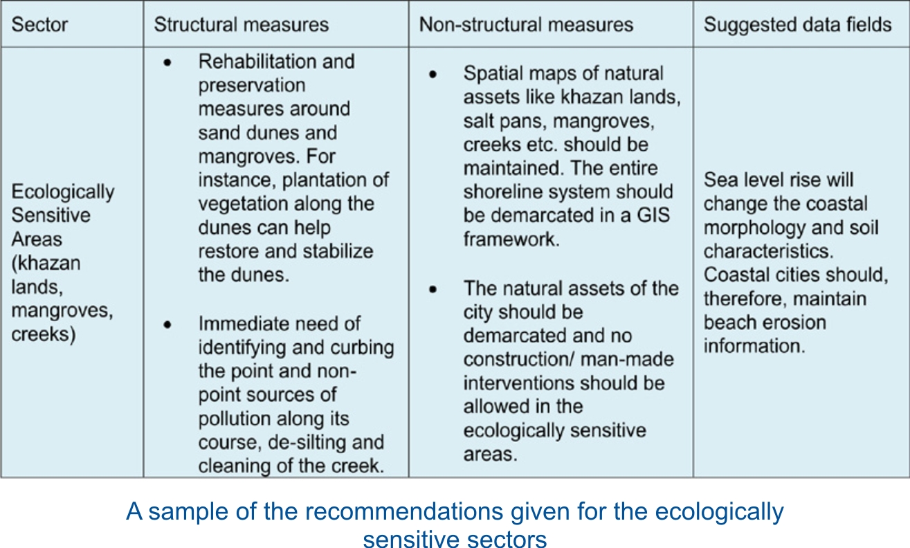
The study essentially included a spatial inventory of the city’s infrastructure to show the land use and sector wise infrastructure classification, which were included in the DBMS for instant reference by decision makers and urban planners. For the climatic data, sea level rise has been considered as the main focus, although precipitation trends for the last few years, sea level trends and proposed rise have also been taken into account. This analysis has helped in listing out the vulnerable zones which are Khazan land and mangroves and the creeks and sand dunes in and around Panaji.
This listing was followed by a sensitivity/ vulnerability mapping analysis of the city systems. The SLR scenarios and infrastructural assets were overlaid on the city’s DEM to give us an indication of the sector wise assets that would be impacted and the severity of the impacts.
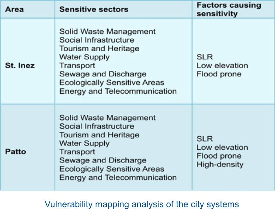 The table thus
helps in identifying the most vulnerable areas and systems in the city that
require imperative attention and action. The study in its concluding remarks
points out that water supply, solid waste management, sanitation, transport
and social infrastructure systems in the city are most vulnerable. Also, the
ecologically sensitive areas are being continuously threatened. The adaptive
capacity of the city was also reviewed by analysing state level documents,
laws and guidelines and conducting discussions with sectoral experts and
planners.
The table thus
helps in identifying the most vulnerable areas and systems in the city that
require imperative attention and action. The study in its concluding remarks
points out that water supply, solid waste management, sanitation, transport
and social infrastructure systems in the city are most vulnerable. Also, the
ecologically sensitive areas are being continuously threatened. The adaptive
capacity of the city was also reviewed by analysing state level documents,
laws and guidelines and conducting discussions with sectoral experts and
planners.
This factual and scientific exercise shall be the initial step in a series of such studies to help cities identify their weakest areas and for planners and decision makers to refer to while looking for realistic and practical solutions to urban developmental issues. ■
Kavya Arora
References: